
The Tour of Colorado Loop is a true adventure! Covering 1,300 miles over 14 riding days, this trip includes all of the best roads and the most famous destinations in the entire state. Riders will experience mountains, winding canyons and rolling forests and meadows. Step back in time when you visit historic settlements and ancient Native American structures.
Although we have organized this into 14 riding days, it is recommended to include rest days, so this could easily stretch into a 3 week trip! Furthermore, some of these riding days might be too long, especially if riders want to stop and explore, so be sure to plan ahead for stopping locations early in the day.
Here are the details:
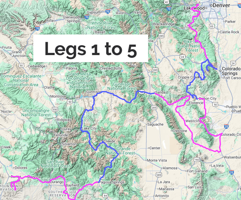
Leg 1: Golden to Colorado Springs
Location: Central Colorado
Approximate Mileage: 115 miles
Estimated Riding Time: 4.0 Hours
Surface: Paved
Attractions: Buffalo Bill Museum and Grave, Lookout Mountain, Lookout Mountain Nature Center, Lair O’ the Bear Park, Tiny Town, Garden of the Gods.
Leg 2: Colorado Springs to Canon City
Location: Central Colorado
Approximate Mileage: 140 miles
Estimated Riding Time: 5.0 Hours
Surface: Paved
Attractions: Garden of the Gods, Manitou Cliff Dwellings, Cave of the Winds, Pikes Peak, Crystal Reservoir Devil’s Playground, Victor Pass, Historic Colorado Mining Country, Cripple Creek, Cripple Creek Jail Museum, Royal Gorge Bridge, Skyline Drive
Leg 3: Canon City to Salida
Location: Southern Colorado
Approximate Mileage: 225 miles
Estimated Riding Time: 4.75 Hours
Surface: Paved + ½ mile gravel with paved bypass.
Attractions: San Isabel National Forest, Cotopaxi Store
Leg 4: Salida to Pagosa Springs
Location: Southern Colorado
Approximate Mileage: 230 miles
Estimated Riding Time: 4.0 Hours
Surface: Paved
Attractions: Monarch Pass, Monarch Rock Springs Water, Lake San Cristobal Overlook, Windy Point Observation Site, Clay Mine - Creede, Post Office Rock, Wolf Creek Pass, Wolf Creek Pass Tunnel, San Juan Overlook
Leg 5: Pagosa Springs to Cortez
Location: Southwest Colorado
Approximate Mileage: 200 miles
Estimated Riding Time: 5.0 Hours
Surface: Paved
Attractions: Chimney Rock Nat’l Monument, Durango, Silverton Train, Mesa Verde Nat’l Park, Weatherhill Mesa, Mesa Top, Cliff Palace Loop.
Leg 6: Cortez to Telluride
Location: Southwest Colorado
Approximate Mileage: 185 miles
Estimated Riding Time: 4.5 Hours
Surface: Paved
Attractions: Narraquinnep Reservoir, Canyon of the Ancients Visitor Center, Durango, Pinkerton Hot Springs, Coal Bank Pass, Molas Pass, Silverton Overlook, Silverton, Ophir Pass Entrance, Black Bear Pass Entrance, Red Mountain Overlook, Bear Creek Falls Switzerland of America Overlook, Ouray, San Juan Mtns Scenic View, Million Dollar Highway
Leg 7: Telluride to Rangely
Location: Western Colorado
Approximate Mileage: 260 miles
Estimated Riding Time: 6.5 Hours
Surface: Paved
Attractions: Hanging Flume Overlook, Driggs Mansion, Colorado National Monument, Douglas Pass, Canyon Pintado South Interpretive Site, Waving Hands Interpretive Site, Kokopelli Site, White Birds Site, State Bridge Interpretive Site, BLM Rest Area - Rangley, Hoodoo Petroglyph Site, Lookout Point Interpretive Site
Leg 8: Rangely to Palisades (Grand Junction)
Location: Northwest Colorado
Approximate Mileage: 250 miles
Estimated Riding Time: 6.0 Hours
Surface: Paved
Attractions: Dinosaur National Monument, Plug Hat Butte, Escalante Overlook, Canyon Overlook DNP, Iron Springs Bench Overlook, Echo Park Overlook, Harper’s Corner, SE Island Park Overlook, CO-134 Train Tunnel, Rifle CO, Parachute CO
Leg 9: Palisades (Grand Junction) to Hotchkiss
Location: Western Colorado
Approximate Mileage: 225 miles
Estimated Riding Time: 6.0 Hours
Surface: Paved
Attractions: Grand Mesa Scenic Byway Sign, Plateau Valley Observation Site, Grand Mesa Visitor Center, Crystal Dam, Black Canyon Visitor Center, Pulpit Rock Overlook, South Rim Viewpoint, Morrow Point Dam, Blue Mesa Dam, Pioneer Lookout Point, Hermit’s Rest, Morrow Point Lookout, Crawford State Park
Leg 10: Hotchkiss to Fairplay
Location: Central Colorado
Approximate Mileage: 275 miles
Estimated Riding Time: 7.0 Hours
Surface: Paved
Attractions: Paonia, McClure Pass, Hayes Creek Falls, Coal Basin Memorial, Redstone Coke Over Historic District, Aspen, Independence Ghost Town, Independence Pass, Collegiate Peaks Overlook, Eleven Mile State Park, Terryall Waterfall Reservoir
Leg 11: Fairplay to Kremmling
Location: Northern Colorado
Approximate Mileage: 275 miles
Estimated Riding Time: 6.75 Hours
Surface: Paved
Attractions: South Park City, Hoosier Pass, Breckenridge, Sapphire Point-Lake Dillon, Pass Lake, Loveland Pass, Eisenhower Tunnel, Kokomo Landmark, Camp Hale Historic Monument, Red Cliff, Red Cliff Bridge, Black Sulphur Springs, Steamboat Springs, Road to Gore Pass.
Leg 12: Kremmling to Estes Park
Location: Northern Colorado
Approximate Mileage: 225 miles
Estimated Riding Time: 5.75 Hours
Surface: Paved
Attractions: Illinois River Overlook, Moose Visitor Center, Cameron Pass, Kinikinik Store, Estes Park
Leg 13: Estes Park to Bergen Park (Evergreen)
Location: Northern Colorado
Approximate Mileage: 175 miles
Estimated Riding Time: 6.5 Hours
Surface: Paved
Attractions: Rocky Mountain National Park (including several pull-offs and overlooks), Alpine Visitor Center, Berthoud Pass, Berthoud Falls, Mount Evans (Mount Blue Sky)
Leg 14: Bergen Park (Evergreen) to Golden
Location: Central Colorado
Approximate Mileage: 230 miles
Estimated Riding Time: 7.5 Hours
Surface: Paved
Attractions: Central City, Nederland, Estes Park, Golden Arch
Tour of Colorado Loop
If you are riding with a group, we ask that every person using our route for navigation purchase their own copy.
In order to encourage this, we are happy to offer a discount for group purchases. Please contact us after purchasing 1 item at full price, and we will set up a coupon code that will give everyone in your group 50% off of the same item.
Our digital routes are designed to operate in most GPS devices. In addition to GPSs, our routes should work with several smartphone apps.
We have tested many Smartphone Apps and here is what we have found:
Please Note
- Some Smartphone Apps require a paid version to allow importing routes.
- Testing was for ‘Follow the Line” only, not “Turn by Turn”.
- If you use an app not listed below, let us know and we will try to test it for you.
- We are not experts on Smartphone Apps. We will try to answer any and all questions, but there may be better resources online.
Apps That Will Work With Our Routes:
- REVER
- Scenic (IOS Only)
- Kurviger (Android Only)
- Detecht
- OsmAnd
- Avenza
- Calimoto
- Gaia
- Ride with GPS
- GPS Tracks
- InRoute
- Harley Davidson
- Indian Ride Command
- My Triumph
- GPX Viewer 2
- Garmin Explore
Apps That Will NOT Work With Our Routes:
- Google Maps
- Apple Maps
- Waze
- Riser
- ESR (Eat Sleep Ride)
- RoadTrippers
- Sygic
- Guru
- Road Warrior Route Planner