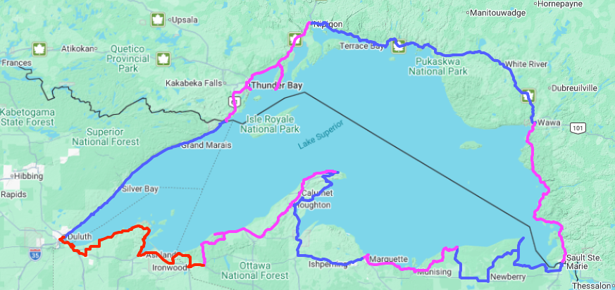

The Lake Superior Circle Tour is a paved multi-day trip around the perimeter of Lake Superior. This 1,500 mile journey takes riders through 3 US States and Ontario Canada. Riders are responsible to bring all documents needed to cross the US/Canada borders
We have divided this ride into 9 different legs, starting in Duluth, MN and travelling in a clockwise direction around the lake. Below (photo) is a list of potential lodging locations and the miles between them.
Leg 1: Duluth to Canadian Border
Starting in Duluth, this leg traces Lake Superior’s Northwest shore to the Canadian border. This ride is full of amazing lake views and waterfalls.
Approximate Mileage: 160 miles
Estimated Riding Time: 3.50 Hours
Attractions: Pierre the Voyager Statue, Two Harbors Depot Museum, Agate Bay Beach, Two Harbors Lighthouse Museum, Two Harbors Circle Tour Stamp Site, Gooseberry Falls State Park, Split Rock Lighthouse Viewpoint, Split Rock Lighthouse, Beaver Falls, Rocky Taconite Statue, Palisade Head, Tettegouche Park, Caribou Falls, Cross River Falls, Father Baraga Cross, Temperance River Falls, Grand Marais Marina Photo Point, Grand Marais Circle Tour Stamp Site, Artists Point, Devil’s Kettle Falls, Heritage Visitor Center, Grand Portage National Monument, Grand Portage State Park
Leg 2: Canadian Border to Nipigon
From the US/Canadian Border, this leg takes riders through Thunder Bay, along the coastline to Nipigon, Ontario. Along the way riders are able to take an out and back side trip through Sleeping Giant Provincial Park.
Approximate Mileage: 165 miles
Estimated Riding Time: 4.5 Hours
Attractions: Pigeon River Provincial Park, Thunder Bay Tour Stamp Site, Boulevard Lake Falls, Terry Fox Memorial Circle Tour Stamp site, Blende River Trestle, Marie Louise Lake Campground, Silver Islet General Store, Sleeping Giant Provincial Park. Nipigon Circle Tour Stamp Site
Leg 3: Nipigon to Wawa
This leg of the trip travels through Ontario, Canada along the Northern shore of the lake from Nipigon to Wawa. At Marathon, the main route veers inland before eventually turning South to end in Wawa.
Approximate Mileage: 233 miles
Estimated Riding Time: 5.50 Hours
Attractions: Nipigon Lookout, Lake Superior Northernmost Point Lookout, Kama Bay Overlook, Gertengiger’s Gas and Variety, Schreiber Circle Tour Stamp Site, Schreiber Beach, Aquasabon Falls, Terrace Bay Circle Tour Stamp Site, Terrace Bay Beach, Terrace Bay Lighthouse, Rest Area Lookout - Ney, Neys Provincial Park, Mink Creek Falls, Marathon Sign, Heron Bay Circle Tour Stamp Site, Hemlo Gold Mine, White Lake Provincial Park, Winnie the Pooh Statue, New Wawa Goose, Wawa Circle Tour Stamp Site, Original Wawa Goose, Dr. Rose’s Beach
Leg 4: Wawa to Sault St. Marie
From Wawa to Sault St. Marie, this leg follows the Eastern shoreline of the lake. While this leg is relatively short, we chose to end in it in Sault St. Marie because of the many things to do and see.
Approximate Mileage: 140 miles
Estimated Riding Time: 3.5 Hours
Attractions: Old Woman Bay Beach, Katherine Cove, Sand River Falls, Agawa Bay Scenic Lookout, Agawa Bay Provincial Park Visitor Center, Alona Bay Scenic Lookout, Pancake Bay Provincial Park, Batchawana Bay Provincial Park, Chippewa Falls Rest Area, Lake Superior Easternmost Point, Harmony Beach, Sault St Marie Circle Tour Stamp Site, SSM Canal Circle Tour Stamp Site
Leg 5: Sault St. Marie to Grand Marais, MI
This leg of the journey is filled with beautiful views and historic sites. The most poignant of which is the Shipwreck Museum and Edmund Fitzgerald Monument at Whitefish Point.
Approximate Mileage: 170 miles
Estimated Riding Time: 3.5 Hours
Attractions: Michigan Welcome Center at Sault St. Marie, South Pond Lighthouse, Point Iroquois Lighthouse, Lake Superior Tahquamenon View, Great Lakes Shipwreck Museum, Lower Tahquamenon Falls, Upper Tahquamenon Falls, Grand Marais, MI Pickle Barrel
Leg 6: Grand Marais to Marquette
The Grand Marais to Marquette leg is another one of the shorter legs of this loop. This leg roughly traces the Lake Superior shoreline between Grand Marais and Marquette, Michigan. Although there is no marker, the southernmost point of Lake Superior is near Munising.
Approximate Mileage: 110 miles
Estimated Riding Time: 2.5 Hours
Attractions: Sable Falls, Log Slide Overlook, Hurricane River Campground, Lake Superior Overlook at Picture Rocks, Munising Falls, Munising Lighthouse, Grand Island Harbor Lookout, Bay Furnace Historic Site, Scott Falls, Lakenenland Sculpture Park, Marquette Maritime Museum, Presque Isle Black Rocks, Sunset Point Presque Isle, Presque Isle Park, Wright Street Falls.
Leg 7: Marquette to Copper Harbor
The leg from Marquette to Copper Harbor is a mix of inland forest and shoreline views. Copper Harbor has many historic sights and scenic views.
Approximate Mileage: 180 miles
Estimated Riding Time: 4.0 Hours
Attractions: Da Yooper Tourist Trap, Canyon Falls, City of L’Anse, Baraga State Park, Baraga Cliff Roadside Park, City of Houghton, City of Gay School, Historic Stamping Mill, Mount Bohemia Resort and Hematite Lookout, Fort Wilkins State Park, Astor Shipwreck Park, North End of US-41, Brockway Mountain Loop Road.
Leg 8: Copper Harbor to Wakefield
Highlights of the ride from Copper Harbor to Wakefield include visits to Porcupine Mountain and Presque Isle Park.
Approximate Mileage: 175 miles
Estimated Riding Time: 4.25 Hours
Attractions: Silver River Falls, Eagle Harbor, Jacob’s Falls, Emil Dyni Der Park, Douglass Houghton Memorial, USS Kearsarge Memorial, Calumet Circle Tour Stamp Site, Agassiz Memorial/Float Copper, Porcupine Mountain, Porcupine Mtn Visitor Center, Presque Isle Park, Carved Wooden Native American Monument.
Leg 9: Wakefield to Duluth
The final leg of this epic journey takes riders along the Lake Superior shoreline in Wisconsin before returning to the starting point in Duluth. This leg is one of the longest and may need to be split up into 2 parts depending on how many stops and side trips riders want to take.
The end of this leg takes riders to Enger Park for one final look at Lake Superior.
Approximate Mileage: 200 miles
Estimated Riding Time: 5.0 Hours
Attractions: Historic Bessemer, Ironwood Circle Tour Stamp Site, Mt. Zion Overlook, Little Girls Point Park, Superior Falls, Michigan’s Westernmost Point, Maslowski Artesian Well, Ashland Circle Tour Stamp Site, Northern Great Lakes Visitor Center, Historic Bayfield, Meyer’s Beach, Port Wing Wayside, Amnicon Falls State Park, Wisconsin Point Beach, Superior Circle Tour Stamp Site, Skyline Lookout, Enger Park